Washington Coast Battered by 35-Foot Waves and Flooding
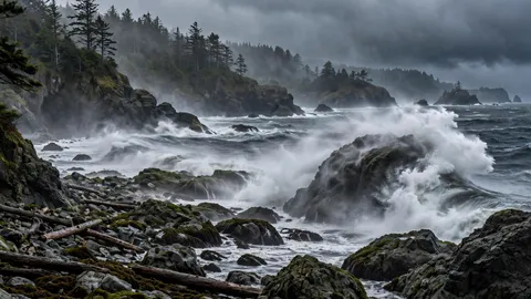
Breaking waves of 30 to 35 feet crashed onto the Washington coast on Friday, November 13, capping a week of storms that knocked out power to more than 115,000 customers, flooded shoreline communities and forced the city of Ocean Shores to declare a citywide emergency. High tides combined with low atmospheric pressure to push seawater onto beaches and low-lying streets, while the National Weather Service warned of extreme sneaker waves capable of sweeping people into the ocean without warning. The surge followed days of hail, damaging wind and record surf, and forecasters said another storm would arrive on Saturday, November 14, bringing gusts of 50 mph and waves of 20 to 25 feet.
Key points
- A week of storms left 115,000 without power on the Washington coast as 35-foot waves flooded shorelines.
- The swell arrives
- Rivers rise inland
- Friday's flood
- Another storm on Saturday
The stormy stretch began with a powerful cold front on Saturday, November 7. Strong thunderstorms near Ocean Shores brought pea-size hail and gusts of 50 to 55 mph, and a gust of 69 mph was measured in Hoquiam at 6:19 p.m. By 9:30 p.m., more than 115,000 customers across western Washington had lost power, including about 46,000 Seattle City Light customers. Trees and power lines came down across the region, and the outages set the tone for a week in which the coast would be hit again and again — first by wind and hail, then by the sea itself.
The swell arrives
On Sunday, November 8, a storm far out over the Pacific sent a huge long-period swell into the Oregon and Washington coast. The National Weather Service warned of breakers of up to 33 feet on the north Oregon and southern Washington coast, and offshore buoys measured significant wave heights of up to 27.6 feet — Buoy 46041 off Cape Elizabeth recorded 27.6 feet at 8:20 a.m. Pacific time. High surf warnings stretched from the northern Washington coast and Grays Harbor to Curry County in southern Oregon.
In Ocean Shores, the surf tore away more than 800 feet of the city's cobble berm, the stone-and-sand barrier that protects the shoreline. On Monday, November 9, the city declared a citywide emergency over shoreline erosion, flooding and prolonged outages, and opened a warming shelter at the Lions Club for residents without power or heat. As of Wednesday morning, November 11, there were no reports of deaths from the waves, but the damage to the shoreline was severe, and crews raced to pile boulders along the shore to protect about two dozen homes and a one-million-gallon water reservoir. The same week, floods swamped Phuket and Bangkok in Thailand, and Cyclone Charles brought flooding to Europe — a season of extreme weather on three continents at once.
Rivers rise inland
While the ocean battered the beaches, an atmospheric river pushed inland, bringing heavy rain and record warmth to the Pacific Northwest. By Tuesday, November 10, seas had built to 20 feet during very high tides, bringing a coastal flood warning and gusts of up to 50 mph. Inland, the Skokomish River in Mason County rose into moderate flooding, putting roads including Highway 106 under water, and a flood watch was issued for Shelton and Elma. Forecasters warned of tidal overflow flooding on Wednesday and Thursday, and of the danger of sneaker waves and beach logs — hazards that have killed beachgoers on this coast in past storms.
The pattern behind the week was a deep Pacific low feeding moisture from the tropics — the phenomenon known as the Pineapple Express — into the region, producing record warmth even as the storms piled up. The low was expected to turn north toward Alaska, but not before sending another round of wind and surf at the Washington coast on Saturday night.
Friday's flood
The worst coastal flooding of the week came on Friday, November 13, when high tides and low pressure pushed water onto shorelines up and down the coast. The National Weather Service issued a Coastal Flood Warning in the San Juan Islands for up to 3 feet of inundation, and forecast breaking waves of 30 to 35 feet along the southern Washington coast near Long Beach and Willapa Bay. The Weather Service office in Portland issued both a High Surf Advisory and a Coastal Flood Advisory for the South Washington Coast, including the Ocean Park, Surfside and Long Beach areas.
The Coastal Flood Advisory ran from noon to 4 p.m. Pacific time on Friday, and the High Surf Advisory from noon Friday through noon Saturday. Forecasters warned of tidal flooding, minor beach erosion and an extreme threat from sneaker waves. Minor tidal overflow flooding of about one foot above ground level was expected in low-lying locations near bays, sloughs and the lower reaches of coastal rivers, and the Toke Point tide gauge near Willapa Bay was forecast to reach approximately 11.2 feet during Friday afternoon's high tide. Forecasters stressed that the 30-to-35-foot breakers did not mean the ocean would rise uniformly 35 feet above the shoreline — but that waves of that size carry tremendous force when they meet shallow water, beaches, rocks and jetties.
Another storm on Saturday
Western Washington braced for another storm on Saturday, November 14, after the week of hail, damaging wind, power outages and coastal flooding. The National Weather Service office in Medford forecast a long-period swell from a storm near the Aleutian Islands peaking on Saturday, with breakers of 30 to 35 feet, while Friday's storm could bring up to a foot of rain to the Olympic Range. The deep Pacific low was expected to turn north toward Alaska while still bringing 50 mph gusts and 20 to 25 foot waves to the Washington coast on Saturday night, and the hail and graupel risk was expected to continue through Monday.
Officials urged residents and visitors to stay off beaches, jetties and dunes during the high surf, warning that sneaker waves can surge far up the beach with no warning and that drift logs can be thrown by the surf with lethal force. For Ocean Shores, the week left a shoreline stripped of hundreds of feet of protective berm, homes exposed to the next storm, and a city still counting the cost of the longest stretch of severe coastal weather in years. As the region digs out, the political world moves on — Democrats swept the 2026 midterms in the same week the storms hit — but on the Washington coast, the next high tide is already the main event.